Taiga Shield
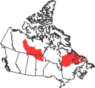
In this map of Canada, the Taiga Shield is located in the red areas.
The Boreal Lake Plateau is located in the Taiga Shield. This ecozone is mostly made up of wetlands, forests, meadows & shrublands. Taking up 1269000km², the Taiga Shield takes up both plains and hills in the Canadian Shield. The Taiga Sheild is part of the Canadian Shield, therefore the bedrock is extremely old dating back almost 4 billion years. Because of the flat and rolling hill terrain, there are lots of lakes and waterlogged areas. There are many rocky outcrops and deposits created by glaciers are scattered around the area.
In this ecozone, the summers are short and the winters are long. The average temperature ranges between 0 and 11 degrees celcius. Precipitation is light to moderate. In an average year, it can rain up to 800mm.
Though forest fires, acid soil and permafrost are quite common in the Taiga Shield, plants still seem to overcome these challenges and grow. The growing season is usually 100-140 days. Black spruce and jack pine are a couple of the natural grown trees in the Taiga Shield. The soil these plants grow in is very thin, highly leched with bare rock spread through-out.
All the lakes and streams attract various species of animals including many herbivores and carnivores. Many types of birds stop and rest near the water while migrating to the south. Barren-ground caribou also migrate south and spend their winters in the Taiga Shield. Over 45 species of mammels live in this ecozone including moose, bears, wolves, coyotes and lynx.
Only about 33,000 people live in the Taiga Shield. Out of those 33,000 people, 60% are first nations. Settlements began during the time of fur trade but now this ecozone is developing because of its hydroelectricity and mining. Miners would be able to find metalic minerals in this area. Most of the populated areas have a lot of untouched land close to it. Mining, fishing, and trapping are still very common.
